Property Record
Scenic Hwy, Snellville, GA 30078
Current Lease Availabilities
NEARBY LISTINGS FOR SALE OR LEASE
Property Detail
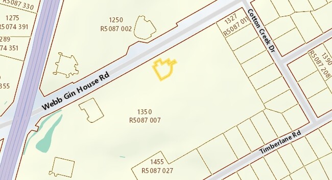
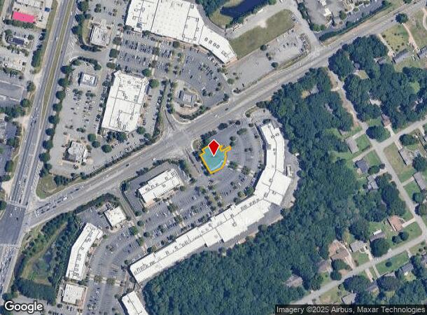
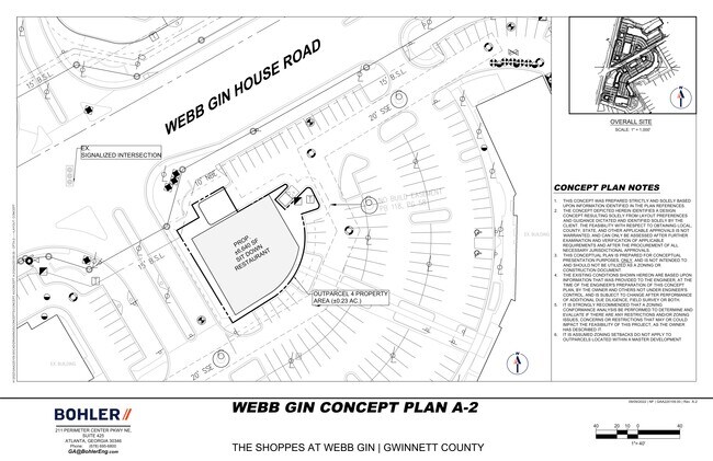
Scenic Hwy
5-087-335
OUTPARCEL #4
Commercialacreage
Gwinnett
X
Georgia
13135C0117F
0.23 AC
0
Lawrenceville/Lilburn
2025
Atlanta
050763
Atlanta-Sandy Springs-Roswell, GA
DEMOGRAPHICS near Scenic Hwy
1 mile
3 mile
5 mile
2024 Total Population
7,264
72,930
199,418
2029 Population
7,555
76,284
208,441
Pop Growth 2024-2029
+ 4.01%
+ 4.60%
+ 4.52%
Average Age
40
39
38
2024 Total Households
2,341
23,452
64,045
HH Growth 2024-2029
+ 4.02%
+ 4.69%
+ 4.61%
Median Household Inc
$108,946
$96,349
$82,775
Avg Household Size
3.10
3.00
3.00
2024 Avg HH Vehicles
2.00
2.00
2.00
Median Home Value
$404,643
$334,027
$296,109
Median Year Built
1995
1994
1994
Nearby Places
Map Layers
Map Styles
 Street
 Aerial
Transit
 Traffic
 Biking
Places
Listings with unknown addresses are not visible on the map
- Restaurants
- Banks
- Shops
- Fitness
- Groceries
PUBLIC TRANSPORTATION
AIRPORT
Hartsfield - Jackson Atlanta International
Drive
Walk
Distance
Hartsfield - Jackson Atlanta International
56 min
36.1 mi
Nearby Properties
Address
Land Use
TOTAL SIZE
Lot Size
Zoning
Address
Land Use
TOTAL SIZE
Lot Size
Zoning
484,262 SF
34.27 AC
RM
Address
Land Use
TOTAL SIZE
Lot Size
Zoning
352,924 SF
86.43 AC
R100
Address
Land Use
TOTAL SIZE
Lot Size
Zoning
362,674 SF
43.59 AC
CI
Address
Land Use
TOTAL SIZE
Lot Size
Zoning
360,279 SF
13.16 AC
RM24
Address
Land Use
TOTAL SIZE
Lot Size
Zoning
349,060 SF
59.85 AC
R100
Address
Land Use
TOTAL SIZE
Lot Size
Zoning
333,734 SF
24 AC
BG
Address
Land Use
TOTAL SIZE
Lot Size
Zoning
271,668 SF
20.13 AC
RM13
Address
Land Use
TOTAL SIZE
Lot Size
Zoning
319,290 SF
2.05 AC
TC-MU
Address
Land Use
TOTAL SIZE
Lot Size
Zoning
221,082 SF
12.90 AC
RM24
Address
Land Use
TOTAL SIZE
Lot Size
Zoning
201,000 SF
29.98 AC
R75
Address
Land Use
TOTAL SIZE
Lot Size
Zoning
245,208 SF
15.37 AC
RO
Address
Land Use
TOTAL SIZE
Lot Size
Zoning
286,368 SF
34.55 AC
R75
Address
Land Use
TOTAL SIZE
Lot Size
Zoning
274,964 SF
27.82 AC
BG
Address
Land Use
TOTAL SIZE
Lot Size
Zoning
214,399 SF
29.91 AC
C2
Address
Land Use
TOTAL SIZE
Lot Size
Zoning
230,417 SF
24.09 AC
BG
Address
Land Use
TOTAL SIZE
Lot Size
Zoning
309,156 SF
17.39 AC
OI
Address
Land Use
TOTAL SIZE
Lot Size
Zoning
214,082 SF
18.56 AC
BG
Address
Land Use
TOTAL SIZE
Lot Size
Zoning
59,949 SF
71.12 AC
C1
Address
Land Use
TOTAL SIZE
Lot Size
Zoning
188,659 SF
5.03 AC
RM13
Address
Land Use
TOTAL SIZE
Lot Size
Zoning
132,916 SF
10.23 AC
BG
Address
Land Use
TOTAL SIZE
Lot Size
Zoning
160,939 SF
25.46 AC
R75
Address
Land Use
TOTAL SIZE
Lot Size
Zoning
148,880 SF
23.15 AC
R100
Address
Land Use
TOTAL SIZE
Lot Size
Zoning
145,715 SF
16.90 AC
BG
Address
Land Use
TOTAL SIZE
Lot Size
Zoning
125,097 SF
1.01 AC
CI
Address
Land Use
TOTAL SIZE
Lot Size
Zoning
357,243 SF
59.63 AC
R100
Address
Land Use
TOTAL SIZE
Lot Size
Zoning
118,804 SF
17.66 AC
C2
Address
Land Use
TOTAL SIZE
Lot Size
Zoning
128,054 SF
15.62 AC
BG2
Address
Land Use
TOTAL SIZE
Lot Size
Zoning
105,948 SF
1.24 AC
BG
Address
Land Use
TOTAL SIZE
Lot Size
Zoning
101,193 SF
5.34 AC
C2
Address
Land Use
TOTAL SIZE
Lot Size
Zoning
51,704 SF
17.25 AC
OI
The World's #1 Commercial Real Estate Marketplace
Connect with us
© 2026 CoStar Group
The information above has been obtained from sources believed reliable. While we do not doubt its accuracy we have not verified it and make no guarantee, warranty or representation about it. It is your responsibility to independently confirm its accuracy and completeness. Any projections, opinions, assumptions, or estimates used are for example only and do not represent the current or future performance of the property. The value of this transaction to you depends on tax and other factors which should be evaluated by your tax, financial, and legal advisors. You and your advisors should conduct a careful, independent investigation of the property to determine to your satisfaction the suitability of the property for your needs.